Gas leak survey transformed through data and analytics.
With MaxSurvey, collect, integrate, and display millions of critical data points within a single, easy-to-understand interface. Manage every aspect of your program with uncompromised quality control and unlimited business intelligence.
understand the present | protect the future
Operational intelligence with every step.
MaxSurvey revolutionizes gas leak surveys by introducing operational intelligence at every step. With a focus on high-accuracy geospatial coordinates, real-time visibility, and prescriptive analytics, it accelerates programs, providing a comprehensive dataset for precise mapping and continuous improvement. The solution seamlessly integrates critical data, offers intuitive dashboards for real-time insights, and sets a new standard with equipment-agnostic innovation, ensuring operational excellence and ushering in a new era of gas leak surveying.
Revolutionizing gas leak surveys.
MaxSurvey transforms gas leak surveys by elevating operational intelligence. From high-accuracy geospatial coordinates and seamless data integration to intuitive dashboards, precise mapping, and equipment-agnostic innovation, it ensures unparalleled efficiency and effectiveness in every aspect of your gas leak survey program. Welcome to a new era of gas leak survey excellence.
Collect, process, and analyze critical data
MaxSurvey accelerates gas leak survey programs with high-accuracy geospatial coordinates, real-time visibility, and prescriptive analytics. From instrument readings to GNSS metadata, it provides a comprehensive dataset seamlessly integrated into a geospatial environment, ensuring precise mapping and continuous program improvement.
Seamless data integration
Designed for maximum configurability, MaxSurvey autonomously consolidates data into a single authoritative database, easily adapting to your policies and workflows. The solution ensures interoperability with systems like GIS (Esri ArcGIS, GE Smallworld), ERP (SAP, Oracle), and EAM (IBM Maximo), eliminating analog input, and auto-generating required reports for streamlined operations.

Optimized ease of access for real-time operational intelligence.
Intuitive dashboards for operational intelligence
Easily assess program data with MaxSurvey’s intuitive dashboards, offering real-time insights into completion dates, compliance, and contract performance. With high-accuracy location breadcrumbs, at-a-glance program status, and transparent tracking, it eliminates the need for paper maps and reports, reducing regulatory reporting time from days to minutes.
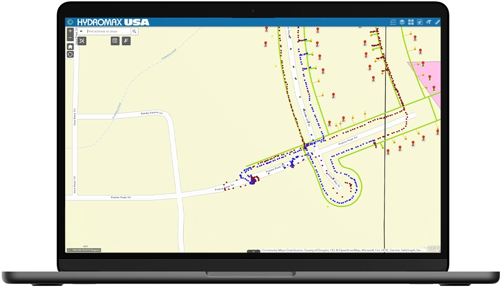
Mapping accuracy & precision
Ensuring verifiable, accurate, and complete programs, MaxSurvey delves into the nuances of GPS technology, digital-twin mapping, and precise digitization. Understanding mapping systems and methods prevents distortions, ensuring correct placements and accurate distances. The solution supports high-quality reference mapping, critical for data integrity.
Equipment agnostic innovation
MaxSurvey sets a new standard in gas leak survey technology by integrating seamlessly with any device from any vendor. With unrestricted access to cutting-edge technologies, continuous monitoring, and ongoing research and development with partners like the Gas Technology Institute, it optimizes individual technician behavior for enhanced effectiveness.
MaxSurvey redefines gas leak surveys, focusing on high-accuracy geospatial coordinates, seamless data integration, and equipment-agnostic innovation. This transformative solution ensures operational excellence, real-time visibility, and prescriptive analytics, setting a new standard in the industry. Step into the future of gas leak surveying with MaxSurvey.
Decades of data expertise
As an ESRI Silver Partner, our technology center is home to a dedicated team of over 70 full-time GIS professionals who bring a wealth of expertise in the development of client dashboards. These specialists have decades of experience working with client infrastructure data from across the country providing client information management, infrastructure program analytics, and value-driven reporting.

2003
Two decades of experience
95M
Asset data points collected

70+
Data analysts, developers, and GIS specialists in our technology center

Esri
Silver Partner
Connect with a utility expert for a demo.
Submit your details below to learn more about our Advanced Field Services and Utility Solutions.