Precise multi-sensor inspections for large-diameter pipelines.
We’re revolutionizing the way professionals inspect pipelines by integrating digital CCTV with multiple sensors, such as Laser/LiDAR and SONAR equipment to generate corrosion or ovality reports.

understand the present | protect the future
Precision inspection redefined.
Hydromax USA leads the transformation in pipeline inspections by integrating digital CCTV with cutting-edge sensors like Laser/LiDAR and SONAR equipment to generate detailed corrosion and ovality reports. As pioneers in multi-sensor inspections, Hydromax USA delivers game-changing data collection and analysis, presenting customers with insightful information that swiftly reveals corrosion, sedimentation, and structural defects.
Transforming pipeline inspections.
Our multi-sensor inspection solution comprises any combination of inspection technologies, such as camera, sonar, and laser, and is deployed in conjunction with our MaxSense MultiSensor Software Solution. The key is to present the data in an efficient, easy-to-understand format that accurately describes corrosion, sedimentation, and structural defects. Hydromax USA has significant experience with several multi-sensor technologies offering advanced capabilities, such as continuous & simultaneous data collection with easily interpreted data in open-source formats.
Hydromax USA is a multi-sensor inspection pioneer, specializing in the integration of digital CCTV and multiple sensors, including laser and SONAR equipment, and the interpretation and presentation of the raw data. We generate highly accurate profiles, geo-reference above and below water objects, and correlate this information to existing grids or coordinates.
Our proprietary and innovative data collection and analysis is a game-changer. We present our customers with the most insightful data that is efficient and easily interpreted – accurately and quickly revealing corrosion, sedimentation, and structural defects.
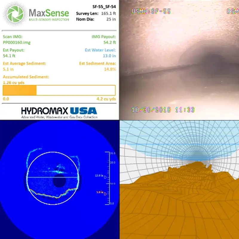
A deeper look at sonar inspection.
Sonar technology uses an acoustic beam to profile the interior of liquid-filled pipes. It is a reliable inspection technology used to inspect sewers below the water surface and is generally used:
- On fully or partially submerged pipes or siphons
- Bypass pumping is not required
- To quantify debris or sediment (ie lost capacity) in a line
- To identify gross anomalies
- In pipes ≥ 12″
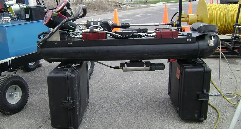
Sonar equipment can be skid, float, or tractor-mounted. Hydromax USA has portable systems mounted on all-terrain, amphibious vehicles for sites with challenging access issues.
Understanding the integrity of your pipelines.
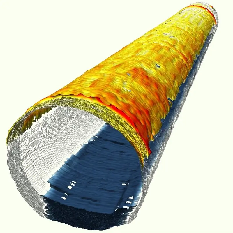
Hydromax USA revolutionizes the inspection of larger-diameter pipelines by employing advanced 2D and 3D Lidar technology alongside CCTV for a comprehensive assessment. Lidar not only reveals corrosion levels and ovality but also addresses the challenge of accurately gauging wall loss, which is often elusive through visual inspections alone. This precision significantly enhances inspection accuracy, empowering owners to make informed decisions about tailored rehabilitation or the potential need for pipeline replacement. Lidar inspections, cost-effective in comparison to traditional rehabilitation or replacement, allow owners to optimize project budgets while maximizing results. Beyond corrosion, Lidar also identifies ovality, providing crucial data on deformations, including the exact percentage of lost cross-sectional area. Choose Hydromax USA for unparalleled accuracy, cost savings, and informed pipeline management decisions.
Comprehensive sewer programs driven by data.
Hydromax USA has built a reputation for quality infrastructure condition assessment and maintenance programs that integrate field services, data, and technology resulting in meaningful, actionable business intelligence for our clients. Our programs optimize wastewater collection system performance and reliability, control inflow, infiltration, and SSOs, and prioritize pipeline renewal programs. Our experienced team has assessed millions of feet of collection system pipelines and provided information management services for utilities across the United States.
Decades of data expertise
As an ESRI Silver Partner, our technology center is home to a dedicated team of over 70 full-time GIS professionals who bring a wealth of expertise in the development of client dashboards. These specialists have decades of experience working with client infrastructure data from across the country providing client information management, infrastructure program analytics, and value-driven reporting.

2003
Two decades of experience
95M
Asset data points collected
1.5M
LF large-diameter multi-sensor inspections. (>30”)

Esri
Silver Partner
Connect with a wastewater program expert.
Submit your details below to learn more about our Advanced Field Services and Utility Solutions.